Unmanned Aerial Vehicles (UAVs), more commonly called drones, are opening up an entire gamut of challenges and opportunities. Today, it is no longer restricted to defence and surveillance.
The drone technology has progressed radically and provided new applications for all major industries. Countless start-ups offer drone technologies for various industries. Drones offer safe and cost-effective solutions across industries like agriculture, construction, mining, public safety and first responders, oil & gas, survey engineering, telecommunications and utilities.
The power utility sector across the world is facing a huge transition, not just because of the economic and environmental forces, but through rapid technological changes. Usage of drones for various functions is being considered by many power utility companies across the world. Some key benefits of drones are that they cut operation and maintenance cost, they boost worker safety because they are able to fly in potentially dangerous areas, they use no fuel, and they have a scant environmental impact. With their traditional imaging capabilities, drones are being increasingly employed to support utility monitoring and maintenance, particularly of transmission lines and other infrastructure where human intervention is impractical or dangerous.
CESC Limited and Noida Power Company Limited (NPCL), utility companies within RP-Sanjiv Goenka Group, have deployed drones for increasing their operational efficiencies.
CESC is an integrated power utility company engaged in the generation and distribution of electricity. The company's operation spans the entire value chain - right from mining coal to generating and distributing power. It serves 3.2 million customers within 567 square kilometers of Kolkata and Howrah, delivering safe, cost-effective and reliable energy to its consumers.
NPCL distributes power in Greater Noida, near Delhi in Uttar Pradesh, which is being developed as an industrial hub and an urban township. It provides service to more than 92,000 customers, in an area spanning more than 335 square kilometres, spread across villages, and a township. Both the companies operate round-the-clock to provide consistent power supply and to deal with any supply outage and rectification work. The service is reinforced through 24-hour call-centre and messaging service to consumers. The companies are always on the lookout for newer technologies to up their ante on consumer centricity and proactive service.
A Bird's Eye View
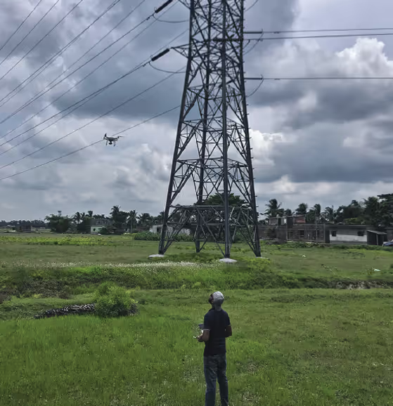
With an objective of introducing new technology that can prove beneficial for improving operations and service, CESC and NPCL took on the challenge to utilise drones in various applications.
The Benefits Are Manifold:
- Drones can fly over rugged terrains, where it is hard for workers to get around, and take pictures.
- They can help to inspect equipment that are situated in hard-to-access areas. The pictures taken with the help of the drones can provide insights where preventive maintenance is required, so that they do not break down unexpectedly.
- The pictures can provide insights on unwanted growth of vegetation over equipment or power lines, which need to be pruned.
- They can help in gaining insight about pilferage of electricity through LT (low tension) network connectivity analysis.
- They can even help to update the land-base, to be prepared for the spreading population that would need new power connections.
Partnering with the right technology
After ascertaining the objectives, a company has to ascertain what type of drone it needs. One can purchase drones directly or use vendors who can provide them on hire.
NPCL floated a request for proposal (RFP), for identifying vendors who could provide the right solution. Kambill Systems was selected as it met the technical and commercial criteria. It offered NPCL a DJI Phantom 4 Pro drone, weighing about 1.38 kg, with a flying height of up to 200 feet above the ground, as per guidelines of DGCA (Directorate General of Civil Aviation). This type of drone, when in operation, has to be in the line-of-sight of the operator. After understanding the solution architecture needed, NPCL also implemented Pix4D – a photogrammetry software developed by a Swiss company that converts images taken by drones into survey-grade accurate and geo-referenced 2D and 3D images.
Kolkata being an old city, the distribution network is more or less underground. The use of drones in the distribution network of CESC, at present, is limited to the measurement of overheated spots in their outdoor yards of Substations and Distribution Stations and for taking corrective actions.
Generating stations at Budge Budge and Haldia cater to the majority of the demand of electricity in Kolkata. These two generating stations, being situated out of the city, have to transmit power to the load centres through 132, 220 or 400 kV overhead transmission lines. Hence, the upkeep of the transmission lines are of paramount importance and using drones for the maintenance of these lines is effective.
CESC went for the hire-and-use model for implementing the usage of drones, as of now, for maintenance of its transmission and distribution (T&D) network.
Drone Classifications
The Government of India classifies drones under the Remotely Piloted Aircraft (RPA) category, and these have further sub-classifications according to their weight. A drone classified in the ‘nano’ category has a weight less than or equal to 250 grams. Slightly bigger drones are classified as ‘micro’, and weigh between 250 grams to 2kg. If a drone weighs between 2kg to 25kg, it is classified in the ‘small’ category. The ‘medium’ category drones weigh between 25kg to 150kg. The final category is called ‘large’, for drones weighing more than 150kg.
An exhaustive list of various types of drones, and other related information, are available in the Digital Sky, an automated portal developed as per the guidelines of the DGCA: https://digitalsky.dgca.gov.in
Getting Started
For a drone that weighs more than 250 grams, there is a mandate for applying for a Unique Identification Number (UIN) and an Unmanned Aircraft Operator Permit (UAOP) from the Directorate General of Civil Aviation (DGCA). The Digital Sky platform handles these kinds of applications and allotments. While a micro drone, operating below 200 feet in uncontrolled airspace or indoors, does not need permission from the DGCA, one has to inform the local police at least 24 hours prior to operating the device. Before operating a drone, the flying area also has to be determined.
Processing the data captured through the drones
A DJI Phantom 4 Pro drone has a powerful camera with a 1 inch 20 megapixel CMOS (complementary metal oxide semiconductor) sensor which is capable of shooting high quality images.
The high resolution photos and videos captured through the drone can be processed to get various types of outputs:
1. Orthomosaic 2D Maps:
Photographs taken by the drone can be collated together for creating orthomosaic, geo-referenced 2D maps of the surveyed area. An orthomosaic, also known as an orthophoto, is an aerial image of an area, composed of multiple photographs stitched together, which has been scaled and geographically corrected for accuracy. These images can be used for analysis of the land-base – the area where the power utility provides electricity.
2. Surface models and reconstructed 3D models, based on point-cloud technique:
A point-cloud is a collection of 3D positions in space. Drones can help to gather point measurements from real-world objects for a point cloud that can then be translated to a 3D mesh, or CAD (computer-aided design) model. These 3D models of equipment that are situated in difficult-to-reach areas due to conditions like heat, height etc., can help to determine if proactive maintenance or periodic maintenance is needed.
3. Video Reports:
High-definition, aerial video reports captured through drones, can be used for maintenance and identifying prospective requirements of power connectivity.
The Benefits
CESC and NPCL have found many benefits using the drone-technology:
Maintenance of Transmission Lines
Videography of the transmission line power corridors and its surroundings, help in more accurate and easier planning of maintenance activities. Getting visuals of the terrain and the area around the transmission lines, are useful to plan the immediate actionables after an incident, for example, line-tripping.
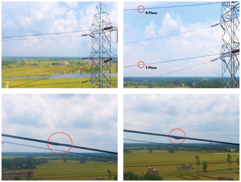
During drone survey of CESC's Subhasgram Substation to EM Substation 220 kV transmission line in June 2019, some abnormalities were detected in the overhead conductors which were not found during earlier surveys. Accordingly, the matter was taken up with immediate effect and resolved.
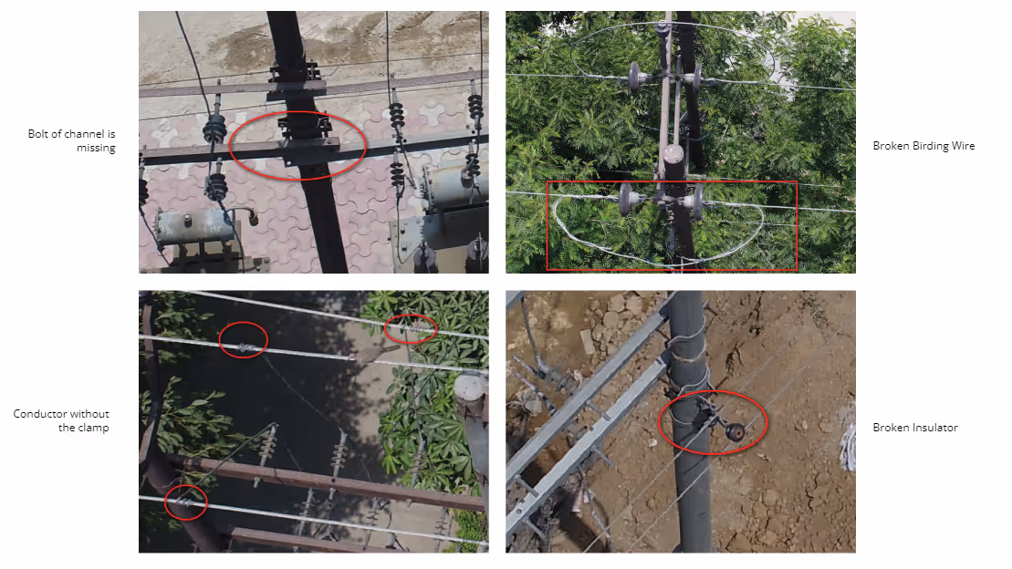
Electric Network Inspection for Preventive Maintenance
For minimizing the probability of fault occurrence, regular inspection of the distribution electrical lines is required. However, even though it is a conventional practice, it is time-consuming, expensive, and at times hazardous for the human workforce. Drones provide efficient, safe, and cost-effective way to perform these inspections periodically.
Similarly, on the transmission side, it helps to manage the towers of the transmission lines by checking for missing parts or rusting, checking the condition of the insulators, jumpers etc. Drones reduce the risk of people having to physically climb on the top of the towers for patrolling. The task of maintaining and inspecting high voltage transmission and distribution lines can be difficult, dangerous and costly. As a result drones can be used as a safe and effective tool to provide assistance in T&D operations.
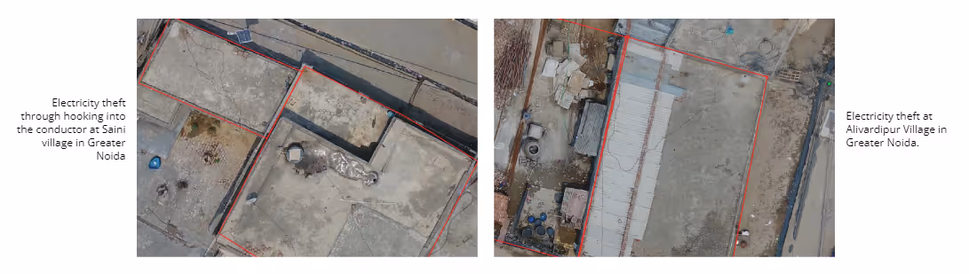
Theft Detection
Majority of the global power theft happens through cable-hooking, which is by direct tapping from the line. Drone surveillance help to identify cases of direct cable-hooking and the high-resolution aerial pictures captured can be presented, as proof, in the court of law. This helps to reduce theft cases, bringing direct financial benefits to the company.
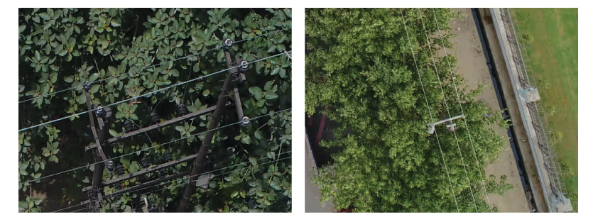
Vegetation Management
Drones help to spot the growth of excess vegetation near the overhead network and infrastructure. These areas are difficult to manually access due to the height. Information regarding the encroaching vegetation is an important part of maintenance, to reduce the risk of fire and other outages.
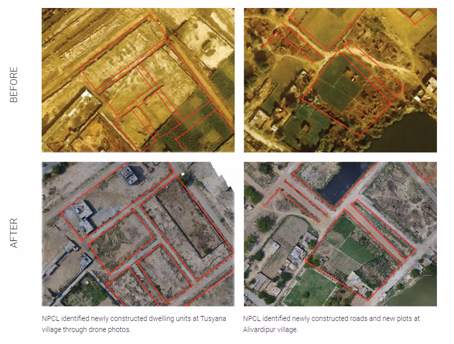
Updating Land-Base
The output from the drones obtained in the form of 2D ortho-mosaic images, are used for updating the land-base data more accurately, especially where the updated satellite imagery is not available. A land base area for a utility is the licensed area for providing services. It is critical for utilities to develop and maintain the highest quality, accurate and most up-to-date land bases possible. Until recently, most conventional vector land bases used by utilities were manually developed and updated periodically. As a consequence they were often out-of-date and less accurate compared to actual changes that had occurred in the field. Drones help to maintain the land bases data much more accurately at a considerably lower cost than previously possible.
Thermal Monitoring of Equipment
Hotspot monitoring of EHV (extra high voltage) and HV (high voltage) equipment and lines are done using drone. CESC, for example, has used a high-resolution thermal camera for infrared thermo-graphic scanning of the 132kV outdoor assets at its Titagarh Receiving Station for detecting hotspots. CESC is now doing a cost-benefit analysis for further scalability.
Applicability to other business areas
As drones continue to be woven into the utilities’ distribution operations, if leveraged properly and with necessary caution, it points to a bright future for the technology in the power industry. More utilities are expected to pursue the implementation of drones in their operations. And with increased adoption, the drone technology is positioned to become a standard, not just in the power industry, but many others. The ability to safely and quickly gather data and to access inaccessible locations, open a world of possibilities.
1. Agriculture
Drones are a natural fit in the world of plantation and agriculture. They can help to track almost anything including requirement of water, crop health and soil analysis.
2. Retail
Using drones to quickly scan thousands of crops in a field is not much different than using drones to scan thousands of items in a warehouse. Large retailers are adopting similar drone technology for inventory management. Drones flying through the warehouse can do a full inventory check in a day, a task that currently can take about a month for people to do manually.
Reference: The flying drones that can scan packages night and day: BBC News
3. Product Delivery
Major online companies are investing significantly to test the use of drones for product delivery
4. Manufacturing
Transport drones are also useful for manufacturers that maintain warehouses. Drones are reliable when it comes to picking the correct product—and when it comes to delivering or putting it back on the shelf. They can also be used to keep the stock organised.
5. Construction
Drones are already used in the construction industry to assist with land surveying and other aspects involved in selecting and managing a construction site. The same technology could apply to manufacturers looking for an optimal site for plant construction.
6. Renewable Energy
Drones can be used for identification and measurement of area for rooftop solar installation. The technology reduces the amount of time the workers spend on the roofs, reduces the probability of measurement errors, and simplifies the maintenance of existing systems — all of which can help to drive down the cost of rooftop solar. Infrared cameras mounted on drones can help detect malfunctions in solar panels and enable faster repairs. For maintenance of wind turbines, drones can be deployed to get close-up, 3D images of wind blades to find out if there are any imperfections without having to stop the turbines from turning. Drones can eliminate redundancy and bring in efficiency, enable precise planning and monitoring, and identify potential issues before they begin to cost dearly. As Indian regulations evolve, drones are expected to set new benchmarks in adding value to the economy.
Read more on the unusual ways in which drones are being used the world over: Business Daily News
For more information on NPCL Saathi, or for any assistance in AI chat bot implementation, please get in touch with:
Mr. Susobhan Bhattacharya
General Manager (Construction)
CESC
E: susobhan.bhattacharya@rpsg.in
M: +91 9831095588
Praveen Goyal
VP - Automation
NPCL
E: pkgoyal@noidapower.com
M: +91 9718065622
Vikas Gupta
Senior Manager - Automation
NPCL
E: vgupta@noidapower.com
M: +91 9718916100